Cloudbase Paragliding is the Australian Flymaster Instruments Importer
C from color. C from competition.
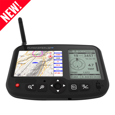
Unleash the power of the LIVE C, where the might and alluring features of the LIVE DS come together in a sleek and compact single-display package. Experience the ultimate fusion of performance, portability, and the unrivaled prowess of LiveTracking technology, proven to be the world’s best. Redefine your navigation experience with unparalleled simplicity, versatility, and the assurance of real-time tracking like never before.
Main Hardware Characteristics
| Display Type | Reflective colour 640x480px |
| Battery Capacity (Lithium-Ion) | 6000 mAh |
| Autonomy Learn more | Usually more than 24 hours (environment conditions may alter this value) |
| Size | 152x90x18 mm |
| Weight | 220 g |
| GPS | 72 channel U-blox BeiDou, Galileo, GLONASS, GPS / QZSS |
| Native USB Connection | USB Type-C Mass Storage Access |
| Battery Charging | From wall adapter or standard usb port |
| GSM | Global Multi-band LTE-M |
| Bluetooth | Bluetooth 5 low energy module |
| Flarm | Flarm ready (optional Flarm Aware RX + TX mode) |
| Micro SD | Supports SDcards up to 256 GB |
| 6 Axis accelerometer and magnetometer | Allows 6-degrees of freedom Tilt-compensated Compass) |
| Firmware update by USB (upgrades are free) |
Interface Features
| User definable pages (each page can be draw using Flymaster Instrument Manager, and include a number of elements only limited by space). | 8 page sets |
| Configurable graphical elements (depending of the element several parameters can be set by the user ex. Size, Border, Color, …) | 15 |
| Configurable data field elements (User can change size, border, title, Font, Color, …) | 85 |
| Page Trigger Events (page switches automatically if a specific event occurs) |
|
| Interface language | English |
| Configurable voice alerts |
|
Variometer/Altimeter Features
- Buzzer/near thermal sound
- Ultra sensitive Variometer with 10 readings per second and 10 cm resolution
- Configurable vario digital filter and integration values
- Fully configurable Vario Sound (frequency, increments, frequency/vertical speed relation,….)
- Adjustable Sound Levels
- Automatic mute, keeps vario silent until takeoff
- Altitude adjustment using QNH
- Automatic altitude adjustment from GPS
- 2 independent altimeters
Memory Features
- 3D flight logger IGC format
3D Airspace
- The map offers an intuitive visualization of restricted areas, ensuring easy identification and awareness of prohibited zones.
- Adjustable voice warning of vertical distance to a restricted area
- Adjustable voice warning of horizontal distance to a restricted area
- Display of shortest vertical, and horizontal distance to restricted area
- Restricted area voice alarms (Altitude imminent, Position imminent, Violation, …)
- Critical Airspace page (displays information about areas that are closer than a defined distance)
- Airspaces browser
- Worldwide Airspace database
Maps
- Detailed colored maps with topographic data
- With configurable layers
Cross Country Features
- Exclusive Thermal Ball indicator
- Several specific data fields like distance to take off, current and average glide ratio, average speed, etc.
- Distance to last thermal indexed with altitude
- Goto waypoint
- Multiple waypoint route
- Wind Speed and Direction (GPS based calculations)
- Automatic altitude gain profiler
- Nearby Landings (displays required glide ratio and distance to all the landings which can be reached)
Competition Features
- Route Optimization (indication for shortest route point)
- Speed to Start (optimal speed to make the start)
- Arriving altitude at next waypoint and goal (considering wind)
- Several Glide Ratios (to goal, average, to next,…)
- Easy task definition
- Task Navigation, configurable safety/risk margin on turn points.
- Task Map (trace with thermal indication)
Live Tracking
- Flight data can be efficiently uploaded to various repositories, such as the Leonardo XC server, XContest, and DHV, utilizing the GSM network.
- Automatic almost real time flight data sending to a remote live tracking server through GSM network. (compatible with several servers like Flymaster, LiveTrack24, DHV, etc)
- On demand sending of predefined messages to a server (eg. Need Assistance, Need Retrieval, etc)
- Effortlessly receive data from a remote server, including alarm messages, task definitions, and more, through automated processes.
- Optimized LTE-M/GPRS data usage is minimal, with an average requirement of only 25KB per flight/hour, assuming uninterrupted communication.
Interfacing
Compatible with MacOS (10.13 and higher), Windows (7/8/10)
72 channel U-blox BeiDou, Galileo, GLONASS, GPS / QZSS | Ultra-sensitive Vario | Built-in Flarm Beacon (no additional subscription needed) | Global Multi-band LTE-M |
New Enhanced Livetracking | USB Type-C Mass Storage Access | NEW Flymaster Instrument Manager Software | Glove-friendly Keys and UI |
Improved Data Fields | New User Interface | Cutside View | Extended Battery Life |
Optional Flarm Obstacles Database | In-instrument Flight Playback | In-flight realtime leaderboard with leading points calculation | Flarm Aware Radar (optional feature) |
In-flight Voice Assistance | Fully Customizable Layouts | Highly visible under direct sunlight | Altitude limits in task definition |
Extra Large Fonts | Optional Bumper Case | U-blox Bluetooth Low Energy | Newest Gen Microprocessor |
 |  | ||
Anti-theft System | High-resistance Protective Lens | Compatible with our Android and IOS App | USB-C to USB-C Connection |
Data transfer over BLE to other Apps |


