
We are the Australian Flymaster Importer. If you can add this product to your cart, this means that it is in stock. No waiting is required, and we can ship to you in most cases on the very next business day.
CLICK HERE TO QUICKLY AND EASILY COMPARE FLYMASTER MODELS

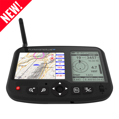
All New! Same FLYMASTER
The GPS M is the ideal instrument for flying non-competition XC flights.

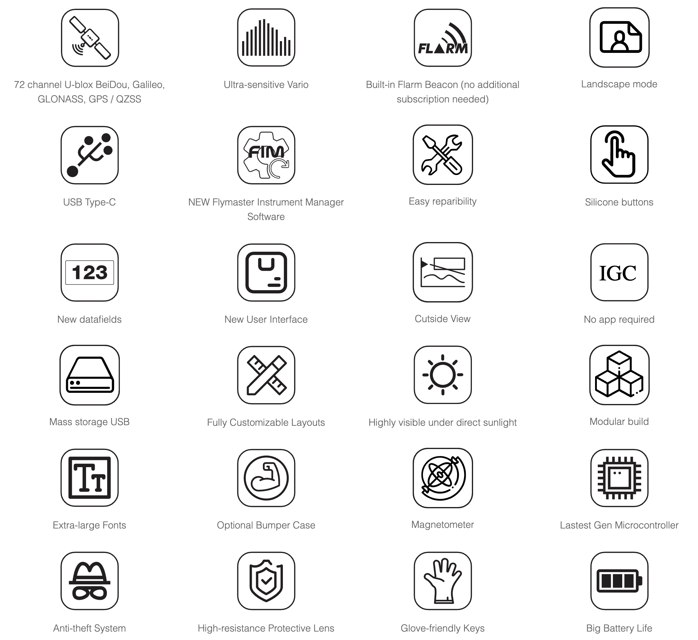
What’s New?
- Better build and sturdiness
- More modular build
- Easier reparability
- Better visibility under direct sunlight (display much closer to the protective lens)
- New User Interface
- USB type C
- Mass storage device capability
- New “cut-side” view
- IGC creation to Mass storage (SD card)
- New landscape mode
- Bigger fonts in landscape mode
- Built-in Flarm beacon as an option
- Optional bumper case
- New buttons for better usability with gloves
- Altitude graph in instrument’s flight log
- Improved Airspaces representation
- Loading waypoints from mass storage file (SD card)
- Works with Flymaster Instrument Manager Software
- Import layouts from instrument
Main Hardware Characteristics
| Display Resolution (High Contrast Grey Scale) | 320×240 pixels |
| Screen size (true viewing area) | 76×57 mm |
| Battery Capacity (Lithium-Ion) | 2900 mAh |
| Autonomy Learn more | Approx. 27 hours |
| Size | 152x90x16 mm (Length x Width x Thickness) |
| Weight | 200 gr |
| GPS | 72 channel U-blox BeiDou, Galileo, GLONASS, GPS / QZSS |
| Native USB C Connection | Allows connection to the PC to download/upload Flight Data, Airspaces Data, etc |
| Battery Charging | From wall adapter, car adapter or standard usb port |
| Micro SD slot | Supports cards to 16 GB, Optional pre-loaded 16GB SD card with airspace, ground data and maps now available. |
| 6 Axis accelerometer and magnetometer | Allows 6-degrees of freedom Tilt-compensated Compass) |
| Firmware update by USB (upgrades are free) |
Interface Features
| User definable pages, 8 in portrait and 8 in landscape mode (each page can be draw using FIM software). | 16 |
| Configurable graphical elements (depending of the element several parameters can be set by the user ex. Size, Border, …) | 11 |
| Configurable data field elements (User can change size, border, title, Font, …) | 61 |
| Page Trigger Events (page switches automatically if a specific event occurs) |
|
| Multi lingual interface |
|
| Configurable audible alerts |
|
Variometer/Altimeter Features
- Buzzer/near thermal sound.
- Ultra sensitive Variometer with 10 readings per second and 10 cm resolution.
- Configurable vario digital filter and integration values.
- Fully configurable Vario Sound (frequency, increments, frequency/vertical speed relation,….).
- 6 Sound Levels (configurable by menu, or using a key).
- Automatic mute, keeps vario silent until takeoff.
- Altitude adjustment using QNH.
- Automatic altitude adjustment from GPS.
- 2 independent altimeters.
Memory Features
- 3D flight logger IGC format.
- Storage for >300000 track points.
- Up to 248 flights.
- 448 Waypoints.
3D Airspace
- Compatibility with Open Air format (upload of files using Designer).
- Display of restricted areas in map
- Adjustable warning vertical distance to a restriced area
- Adjustable warning horizontal distance to a restriced area
- Display of shortest Vertical, and Horizontal, distance to restricted area
- Resctrited area alarms (Altitude imminent, Position imminent, Violation, …)
- Critical Airspace page (displays information about areas that are closer than a defined distance)
- Worldwide Airspace database (SD card required) ( ).
Cross Country Features
- Exclusive Thermal Ball indicator
- Several specific data fileds like Distance to take off, current and avarage glide ratio, avarage speed, etc.
- Distance to last thermal indexed with altitude
- Goto waypoint
- Multiple waypoint route
- Wind Speed and Direction (GPS based calculations)
- Automatic altitude gain profiler
- Nearby Landings (Displays Required Glide Ratio and distance to all the Landings which can be reached)
Route Features
- Several Glides Ratios (average, to next,…)
- Easy route definition
- Route Navigation, configurable safety/risk margin on turn points.
- Route Map (trace with thermal indication)
Interfacing
- Compatible with MacOS (10.13 and higher), Windows (8/10/11)